Multinational Monitor |
|||
|
SEP/OCT 2005 FEATURES: The Storm This Time: A Personal Account of the Natural and Unnatural Disaster in the Wake of Hurricane Katrina Disaster Profiteering: The Flood of Crony Contracting Following Hurricane Katrina Between Soldiers and Bombs: Iraq's Fledgling Labor Movement Takeover Inn Argentina: Argentina's Worker-Run Cooperative Movement INTERVIEWS: The Human Engineering of Catastrophe: Coastal Maldevelopment and Katrina's Wrath The Soul of New Orleans: Asseting Rights of Low- and Moderate-Income Families in Hurricane Reconstruction Restoring the Gulf: An Ecological Agenda DEPARTMENTS: Editorial The Front |
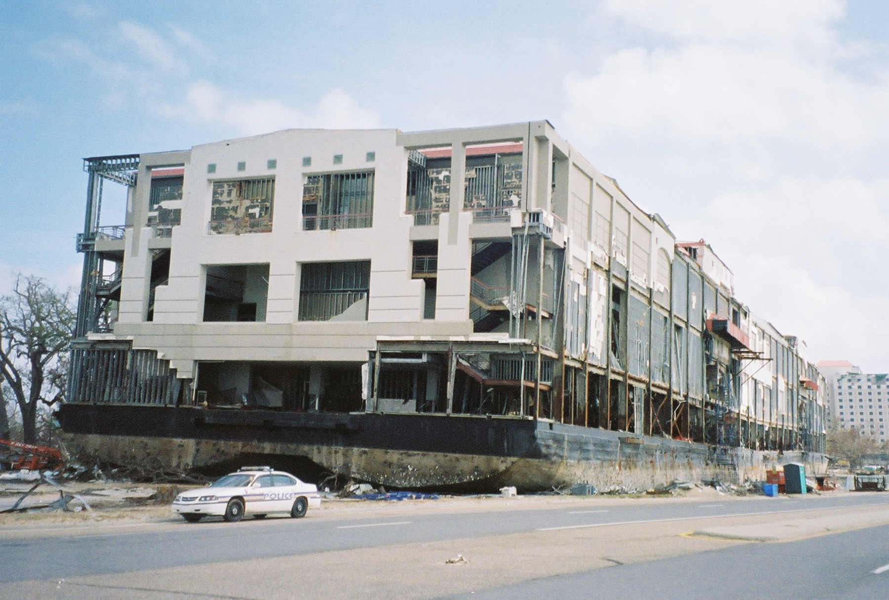
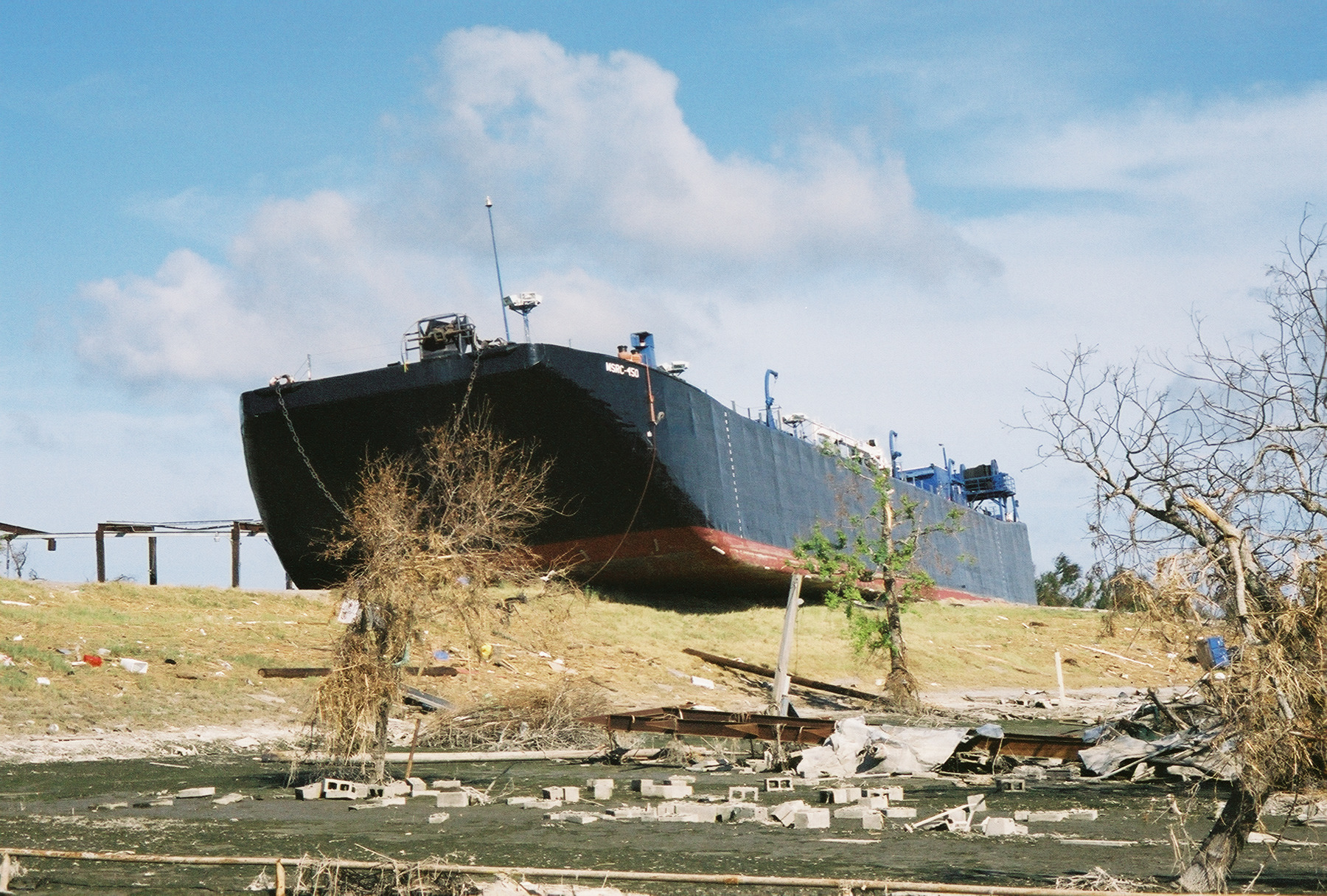
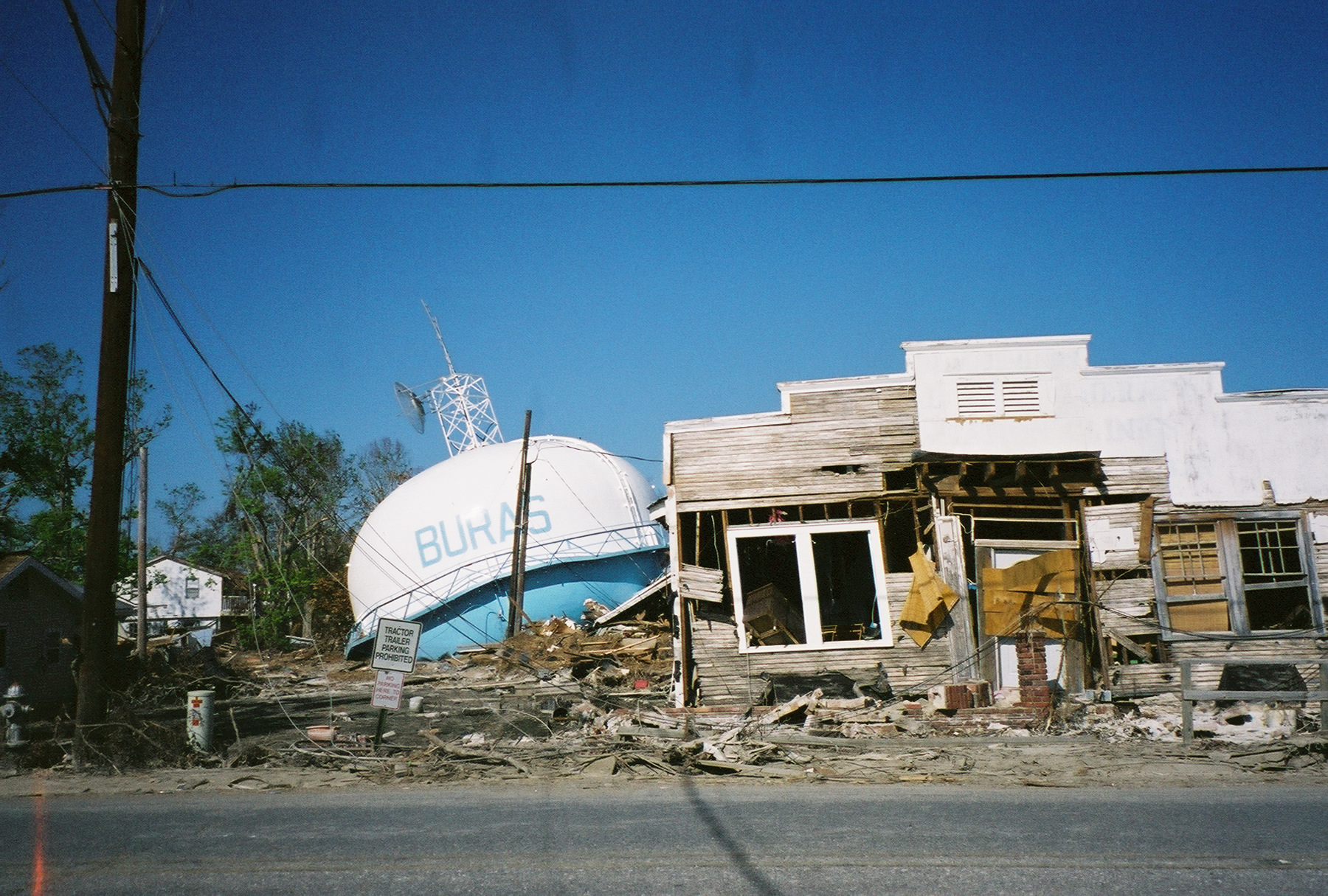
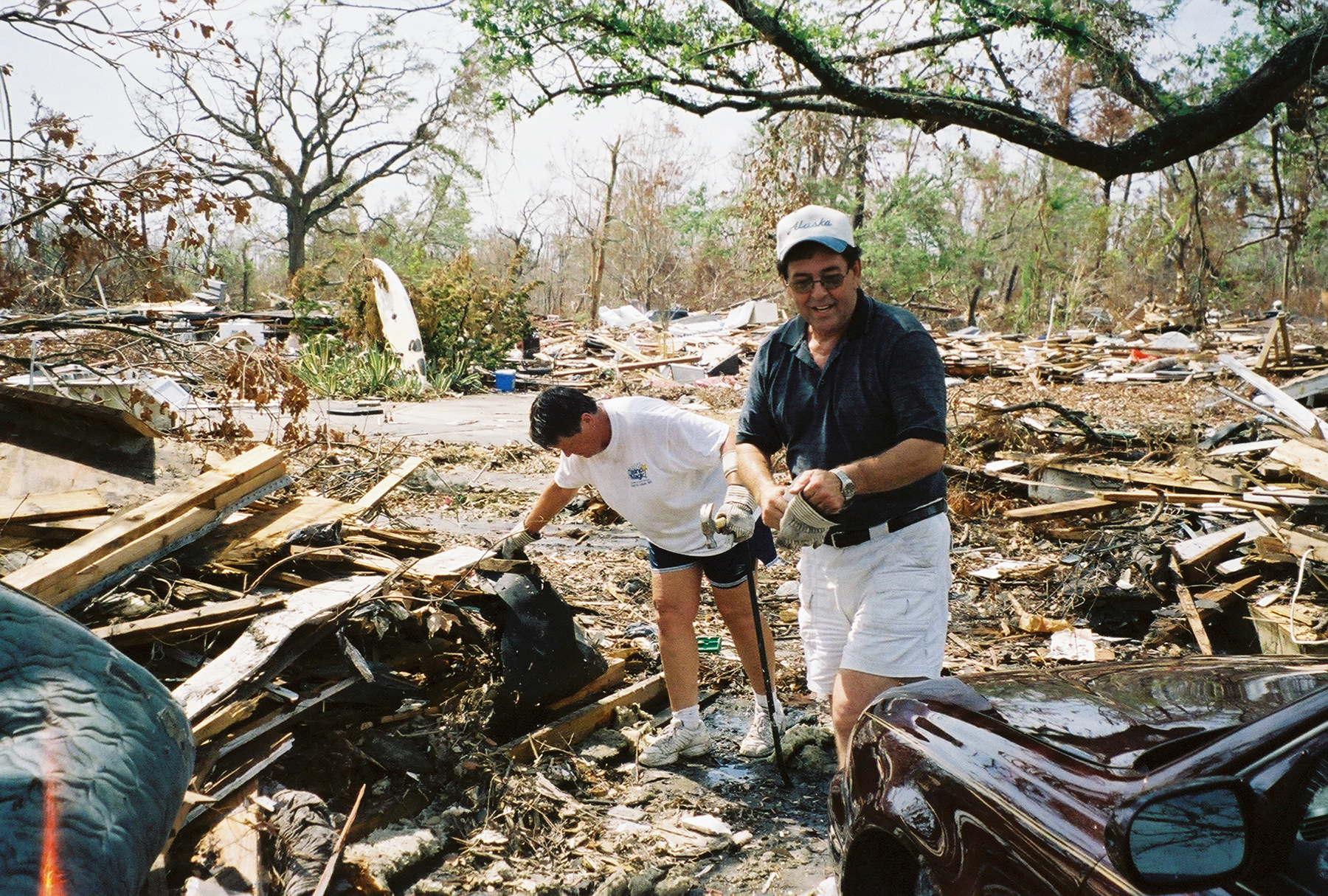
The Storm This Time: A Personal Account of the Natural and Unnatural Disaster in the Wake of Hurricane Katrina There was a complete failure in terms of precautionary actions, preparation and response. O.K., not a complete failure. The National Hurricane Center gave 72 hours warning and the Coast Guard surged in behind the storm to do more than 6,400 flood-water rescues during four days of helicopter flying. “I was involved in about 140 rescues. A lot of rooftops on the first day, more balconies on the second. It was non-stop. We were just hoisting and fueling. It was surreal,” recalls 21-year-old rescue swimmer Keola Marfil. At the opposite end of the competency scale, executive agency decision-makers at the Department of Homeland Security and FEMA left New Orleans and the Gulf without any other federal support for more than 96 hours, resulting in unnecessary deaths and hardship. Clearly the Louisiana National Guard was not up to the task of dealing with more than a million environmental refugees and victims in the state. 5,700 guards were operating out of a flooded headquarters, while a third of the force, 3,200 members, were deployed in Iraq — along with hundreds of their high-water trucks, fuel-trucks and satellite communications gear. Although there is plenty of fault to be found at the local and state level, those with the greatest available resources ought to be held to the highest standards of accountability. Instead, Secretary of Homeland Security Michael Chertoff, in trying to explain why he delayed mobilizing his forces, claimed that no one had ever predicted a disaster of that magnitude (even though FEMA had staged A system of political cronyism had by then established itself within FEMA, beginning with the appointment of Joe Albaugh, Bush’s former Texas chief of staff and campaign director, as FEMA’s director. Albaugh brought his former college buddy Michael Brown into the agency after Brown was put out to pasture as a long-time commissioner with the International Arabian Horse Association. Like Brown, five of the eight top officials at FEMA had no previous disaster-management experience, though they were well connected politically. After punching his ticket for two years, Albaugh resigned to become a lobbyist for high-end clients including Halliburton and the Shaw Group, major post-Katrina government contractors. Mike Brown became the new head of FEMA, assuring that there would be someone left behind to sign the contracts. Later, after FEMA’s well-documented failure to mobilize a timely response to Katrina (partly because Brown’s boss Chertoff didn’t authorize it), Brown — or ‘Brownie’ as President Bush affectionately nicknamed him — was forced to resign, staying on as a $148,000-a-year FEMA consultant. The on-the-ground results of cronyism and myopia were shocking even to the eyes of a hardened reporter. Urban Flood Plain I arrive in Baton Rouge with a planeload of relief workers, FEMA functionaries and crew cut contractors, all working their cell phones and blackberries. After renting a car and making my way through the daily traffic jam (Baton Rouge’s population has exploded since the storm) I head south on Interstate 10, tuning into the United Radio Broadcasters of New Orleans, a consortium of local stations playing 24/7 information and call-in reports on Katrina’s aftermath. A police spokesperson assures listeners there are still 20 to 30 roadblocks around New Orleans and 11,000 guardsmen in the city. The mayor wants to open the city back up to residents but the approach of Hurricane Rita has forced him to postpone his plan. Around the New Orleans airport in Jefferson Parish, I begin to see box stores, warehouses and motels with their roofs ripped off or caved in, downed trees and broken street signs, house roofs covered in blue tarps and high-rises with glass windows popped out like broken eyes. I hit a traffic jam and follow an SUV across the median strip to an exit where I stop to take a picture of a small office complex with its second story front and roof gone. Rain-soaked cardboard boxes fill the exposed floor above a CPA’s office. I talk to a carpet-store owner removing samples. He helps me locate where we are on a map. I get a call from a contact at the New Orleans Aquarium. They lost most of their fish when the pumps failed but managed to evacuate the penguins and sea otters to Monterey. I get on a wide boulevard that leads to a roadblock where a police officer checks my press identification. “This is only for emergency vehicles, but go ahead,” she says. I drive into Lakeview, one of the large sections of the city that sat underwater for two weeks and will likely have to be bulldozed. It reminds me of war zones I’ve been in after heavy street fighting. There are trees and power poles down, electric lines hanging, metal sheets and street signs on mud-caked pavement, smashed cars, boats on sidewalks and torn-open houses, all colored in sepia tones of gray and brown. Unable to drive far in the debris-chocked streets, I get out of my car, half expecting the sweet, rotting smell of death. Instead, I’m confronted with an equally noxious odor. It’s what I’ll come to think of as the smell of a dead city, like dried cow pies and mold with a stinging chemical aftertaste. Fine yellow dust starts rising up from under my boots and infiltrating the car. I retreat. The I-10 exit is barricaded, forcing me The rusted ruined roof of the Superdome inspires me to choose an exit and, after getting turned around at a friendly National Guard checkpoint, I’m soon in the deserted streets of the central business district, checking out the rubble piles and empty highrises. A big wind-damaged ‘Doubletree’ hotel sign reads D UL EE. The French Quarter is still intact with even a few bars open for soldiers, FBI agents and fire fighters. On Canal Street, it looks like a Woodstock for first responders with Red Cross and media satellite trucks, tents and RVs pulled up on the central streetcar median by the Sheraton. Red-bereted troops from the 82nd Airborne cruise by in open-sided trucks, M-4s at the ready in case the undead should appear at sunset. Uptown, some boats lie in the middle of the street, along with cars crushed by a falling wall and a pharmacy trashed by looters. Further on are the smashed homes and muddied boulevards and still-flooded underpasses and cemeteries, abandoned cars and broken levees of an eerily hollow city. In the coming days, I’ll travel across this new urban landscape, tracing the brown floodwater line that marks tens of thousands of homes, schools, offices, banks, churches, grocery stores and other ruined structures, including the main sewage plant. I’ll cross paths with animal rescue crews, military patrols, utility crews from New York and Pennsylvania, and body recovery search teams with K-9 dogs using orange spray paint to mark the doors of still unexamined buildings, writing the date and adding a zero for no bodies or numbers where bodies have been found. A Predicted Disaster “I don’t think anyone anticipated the breech of the levees,” President Bush told Diane Sawyer shortly after this below sea-level city went aquatic, perhaps his most memorable quote since declaring “Mission Accomplished” after the invasion of Iraq. Of course, the U.S. Commission on Ocean Policy that Bush appointed had highlighted the risk of the levees failing in its final report in the fall of 2004. Mark Schleifstein of the New Orleans Times-Picayune had been writing about the risk of a category 4 or 5 hurricane devastating the city for so many years that his editor started calling the stories “disaster porn.” After Katrina struck, he and his workmates got out of their office in the back of big-wheeled newspaper delivery trucks with the flood waters up to their grills. It wasn’t that Katrina was an unprecedented storm. There have been a number of storms — Hurricane Camille in 1969, for one — that blew with almost equal force. The difference is that 36 years ago the Gulf of Mexico had far more protective wetlands and less risky development along the coast (and in coastal flood plains). Also, until recent decades, it was not in the footprint of fossil-fuel-fired climate disruption. Flying over the bayou, I’ve seen shredding islands of brown spartina, or salt grass, crosshatched with canals built by oil companies and flood control channels and levees built by the U.S. Army Corps of Engineers. Historically, the Mississippi River’s flooding deposited sediment that built up the delta. Now these hydrologic speedways flush that sediment out into the deep Gulf. Oil drilling has caused land subsidence, and the burning of coal and oil has raised the sea level by more than a foot. All this has shrunk the wetlands by up to 30 square miles a year in recent decades (Katrina and Rita may have eliminated an additional 20 to 30 square miles). “The Army Corps has given us a levee system that’s traded periodic Mississippi River flooding for permanent coastal flooding, and that to me Did he believe that he could mobilize enough popular will to turn around the forces of sprawl and development, not to mention the Army Corps? “If our advocacy is inadequate to the task,” he said, “then a hurricane will make the case for us.” “Being right sure sucks,” he now says. Life After Katrina I put up with an AP colleague in the less damaged Algiers Point section of the city just across the Mississippi from where the helicopter assault ship Iwo Jima and Carnival Cruise Line ship Ecstasy are being used to house city employees and relief workers. Blackhawk helicopters fly overhead at sunset while a Red Cross truck down the street offers hot food to the handful of residents still here. Back in Lakeview, I encounter Bob Chick. Bob snuck past the checkpoints to see if he can salvage anything from his green Cajun Cottage near where the 17th Street floodwall breached. He hasn’t had much luck, “just some tools that might be OK,” he says. “I left all my photos on top of a chest of drawers thinking the water wouldn’t get that high. They say if you have more than five inches of water in your house for five days it’s a loss. We had eight feet for two weeks.” He’s found one of his cats dead but thinks the other two might have escaped. He invites me to look inside. From the door it’s a jumble of furniture, including a sofa, table, twisted carpet, lamps and wooden pieces all covered in black and gray gunk, reeking of mold and rotted cat food. I try not to breathe too deeply. “I had a collection of Jazz Fest T shirts going back to ‘79 but they’re gone.” He’s wearing a mask, rubber boots and gloves, but still manages to give an expressive shrug of The Bush administration cut funding for the Army Corps’ work on the levees last year, but that was only a tiny part of a larger pattern of neglect and denial going back generations. As I’m driving behind a string of army dump trucks, “Marine One,” a second White House helicopter and an escort gunship fly overhead. Bush has just made his fourth visit in just over a week. U.S. demographics have changed since Katrina. Baton Rouge is now the largest city in Louisiana, its arenas and hotels jammed with evacuees. Like the Dust Bowl of the 1930s, the Storm Bowl of today could result in a new wave of homelessness. Buck Bagot, one of the top homeless-housing organizers in the United States, says there’s a kindly attitude toward the new “deserving” homeless versus the “undeserving” old, but predicts that tolerance may be gone in six months. By mid-October, FEMA is spending $11 million a day on hotel rooms to house the displaced. I meet a group of a dozen Cajuns spending their days and nights in a carport under a damaged three-story office building in Belle Chase, La. There are black and white folks camped out in tents, campers, and an RV under the closed Ocean Springs-Biloxi bridge in Mississippi; there are refugees in marine-lab dorms and KOAs and a Mormon tent colony by a lake; and folks at friends’ and families’ homes, barns and yards, or, as a last resort, evacuation centers. I go to a meeting in Austin, Texas and find my motel is full of New Orleans evacuees more than a month after Katrina. A Disappeared Town I catch a ride along the west bank of the Mississippi in Plaquemines Parish south of New Orleans with deputy Sheriff Ken Harvey. This is where I take a picture of an antebellum white mansion in the water along with a floating pickup, a larger truck hanging off a tree, a semi-trailer cab under the bottom of an uplifted house, a speedboat through a picture window, the Buras water tower collapsed next to a wrecked store, shrimp boats on the levee, on the road and in the bushes with military patrols passing by. We stop and stare in awe at a 200-foot barge tossed atop the levee like a bath toy on a tub rim. Approaching the Empire Bridge, I note the white church facing north towards us is still intact and suggest that’s a hopeful sign. “It used to face the road,” Ken points out. We listen to his boss, the sheriff, on Unity Radio threatening to lay off his people and make the state troopers take over the Parish if he can’t meet payroll by midnight. Late that evening, the governor agrees to hand him $10 million. In what’s left of Port Sulphur, the sheriff’s deputies are living in converted shipping containers (the same kind used on offshore oil rigs). Most of their homes have been washed away. We stop and examine oil that’s spread across the road and into the wetlands where a 20-inch Shell pipeline burst. I take a picture of some collapsed oil storage tanks. On the way out, Ken, who’s fearless when it comes to speeding up and down the sides of levees, gets nervous when I take a picture of a Shell Refinery. Environmental Trouble It’s too early to talk about the hurricanes’ environmental impacts on the coast and ocean with any authority. The oil companies lost at least 52 rigs in the Gulf, with more than 110 others damaged. The Coast Guard’s latest estimate is 9 million gallons of oil were spilled (more than two-thirds of an Exxon Valdez). I visit the Gulf Coast Research Lab in Ocean Springs, Mississippi, which took a big hit, with major buildings lost and flooded (even though it sits on a 20-foot bluff above the water); its 35,000 square foot education center in Biloxi was totaled. Lab Director Bill Hawkins thinks the pollutants in the New Orleans flood waters that were pumped back into Lake Pontchartrain will likely impact the Gulf of Mississippi some time next year. Nancy Rabalais at the Louisiana Universities Marine Consortium (which lost its roof to Katrina and its ground storage and lab vehicles to Rita) still managed to get out on a research cruise between storms. She encountered a 7-foot swamp alligator 15 miles out at sea. Most of the region’s shrimp and commercial fishing fleet was sunk or thrown up onto the land. The possibility that federal fisheries managers might use this as a chance to buy out part of the destroyed fleet in order to reduce fishing pressure was the source of much speculation and little certainty in the wake of Katrina. The 30-mile-long crescent of the Chandeleur Islands, east of Louisiana, are mostly gone. Whether these important barrier islands and bird colonies will re-emerge from the sea in coming decades is unclear. The good news is that many of the live oak, hackberry and cypress that look dead are starting to rebud. Some 25-foot trees survived, along with roads and seagrass meadows, because the storm waves were so high above them that they weren’t scoured away. Unfortunately, as I drive east through Mississippi and Alabama I find I feel like an eco-geek being more concerned about the gulls and wetlands than the lost revenue from the casinos that everyone else seems to be obsessing on. The waterside wing of the new Hard Rock Casino is now a smashed tangle of twisted girders and concrete. I pull over by an 8,000 ton, 600-foot-long casino barge that was pushed half a mile by the storm, landing on Beach Drive. Somewhere underneath its barnacle-encrusted black hull is a historic mansion. Nearby, the Grand Casino barge has taken out much of the stately facade of the six-story yellow brick Biloxi Yacht Club before grounding next to it. Another barge landed on the Holiday Inn, where more than 25 people may have been trying to ride out the hurricane. No one’s been able to do a body-recovery there yet. Because Southern Baptist and other religious conservatives objected to ‘land-based’ gambling in Mississippi, much of Biloxi’s wetlands were torn up to make way for these floating casinos. I talk with Phil Sturgeon, a Harrah’s security agent hanging out with some cops from Winter Park, Florida. He’s in jeans and a gray shirt with a toothbrush and pen sticking out the pocket. He tells me the storm surge crested at about 35 feet, at least five feet higher than Camille in ’69. In Waveland, I drive over twisted railroad tracks where the eye of Katrina passed into neighborhoods of jagged wooden debris. A middle-aged couple is trying to clear the drive to the lot where their home once stood. A surfboard leans up against one of the live oaks that seem to “Are you an adjuster?” the woman asks. “No, a reporter.” “Good, because we don’t like adjusters. Nationwide was not on our side.” Apparently they’ve been offered $1,700 on their $422,000 home. “At least you’ve got your surfboard,” I tell John, her husband, “Oh, that’s not my surfboard,” he grins, pointing around. “And that’s not my boat, and that’s not my Corvette (buried to its hood in the rubble), and that’s not our roof. We think it might belong to the house at the end of the street.” Some 50 million tons of rubble and waste along the Gulf is yet another environmental challenge. The initial plan is to go after the “woody debris” (downed trees) first, then white debris (refrigerators, stoves, etc.), cars, boats, construction materials, building materials, hazardous waste, plastics, etc. Authorities can’t burn it without risking a huge spike in asthma and other lung diseases like happened in Dade County, Florida after Hurricane Andrew in 1992. But they also can’t move much wood out of New Orleans without risking the spread of invasive Formosa termites that have riddled the city. Starting Again I’m back in New Orleans on Canal Street, where the Salvation Army offers me cold water, a baloney sandwich (I decline) and a fruit cocktail. It’s been a long day with the Army Corps of Engineers, who’ve leased helicopters that are dropping 3,000 and 7,000 pound sandbags on the latest breach in the Industrial Canal which has reflooded the Lower Ninth Ward. I enter the Sheraton after getting cleared by muscular Blackwater Security guys in tan and Khaki tee shirts and shorts with Glocks on their hips. Another one sits by the elevators checking room IDs. I wonder if being a The Gulf region is now very much like a war zone, only with fewer deaths (about 1,200 bodies recovered at the time of my visit) and far more extensive damage. It also offers many of the same ironies and bizarre moments. Unity Radio announces that if you’re going to tonight’s Louisiana State University football game in Baton Rouge you can return after curfew provided you show your game stubs to the deputies at the roadblocks. Three years ago I made a decision. I’d lost a key person in my life and was trying to decide what to do next. I was considering either going back to war reporting, as George Bush was clearly planning a pre-emptive invasion of Iraq, or turning from journalism to ocean advocacy as Ralph Nader and others who’d read my ocean book were encouraging me to do. Finally, I decided that while we’ll probably always have wars, we may not always have living reefs, wild fish or protective coastal wetlands. What we know we are going to have are more environmental disasters like the Hurricane Season of ‘05 linked to fossil-fuel-fired climate change and bad coastal policies driven by salt-water special interests. Still, destruction on a biblical scale also offers Noah-like opportunities for restoration after the flood. There are practical solutions to the dangers we confront, along with models of how to live safely by the sea. Things can be done right in terms of building wisely along the coasts, and advancing social and environmental equity. But it will take a new wave of citizen activism to avoid repetition of old mistakes, with even more dire consequences.
David Helvarg is president of the Blue Frontier Campaign (www.bluefront.org) and author of The War Against the Greens, (Johnson Books, 2004), Blue Frontier — Dispatches from America’s Ocean Wilderness (Sierra Club Books, 2006) and 50 Ways to Save the Ocean (Inner Ocean, 2006).
|
||
 I’m flying to New Orleans and the Gulf region by way of Ronald Reagan (Washington, D.C.) and George Bush (Houston) airports to see how “less government” functions in the face of a coastal catastrophe. Actually, given that it’s three weeks since Hurricane Katrina made landfall, we already know the answer.
 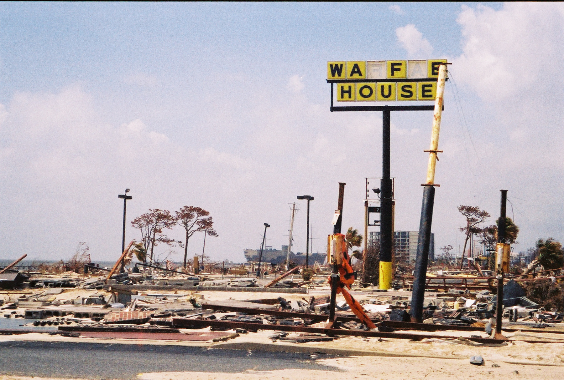 a war-game based on the idea of a major hurricane named “Pam” striking and flooding New Orleans a year earlier).
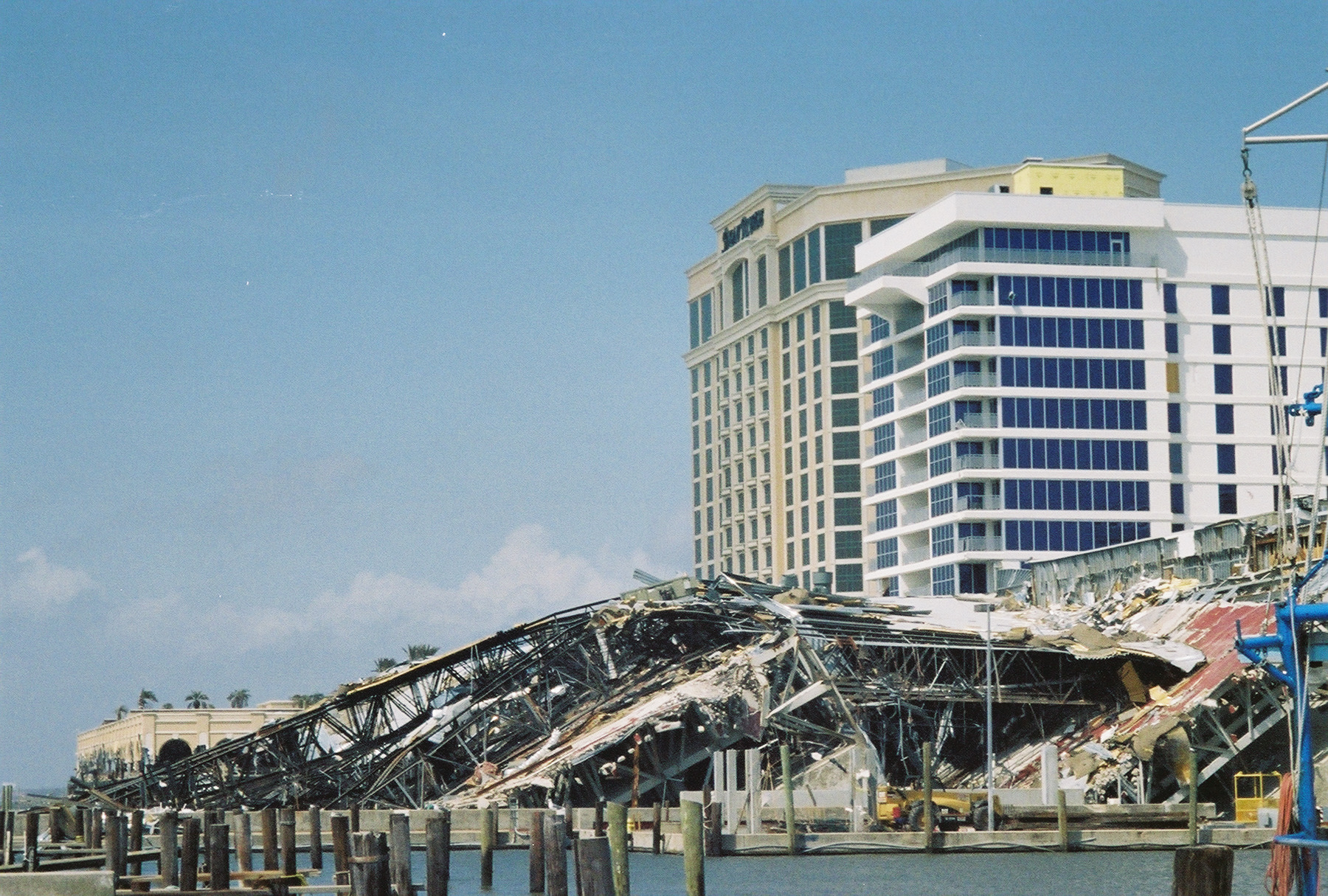
 north again. I do a U-turn at a major roadblock and get chased down by some angry cops. I explain that I’m just following another cop’s helpful directions and soon find myself speeding along a near-empty freeway bridge approaching downtown.
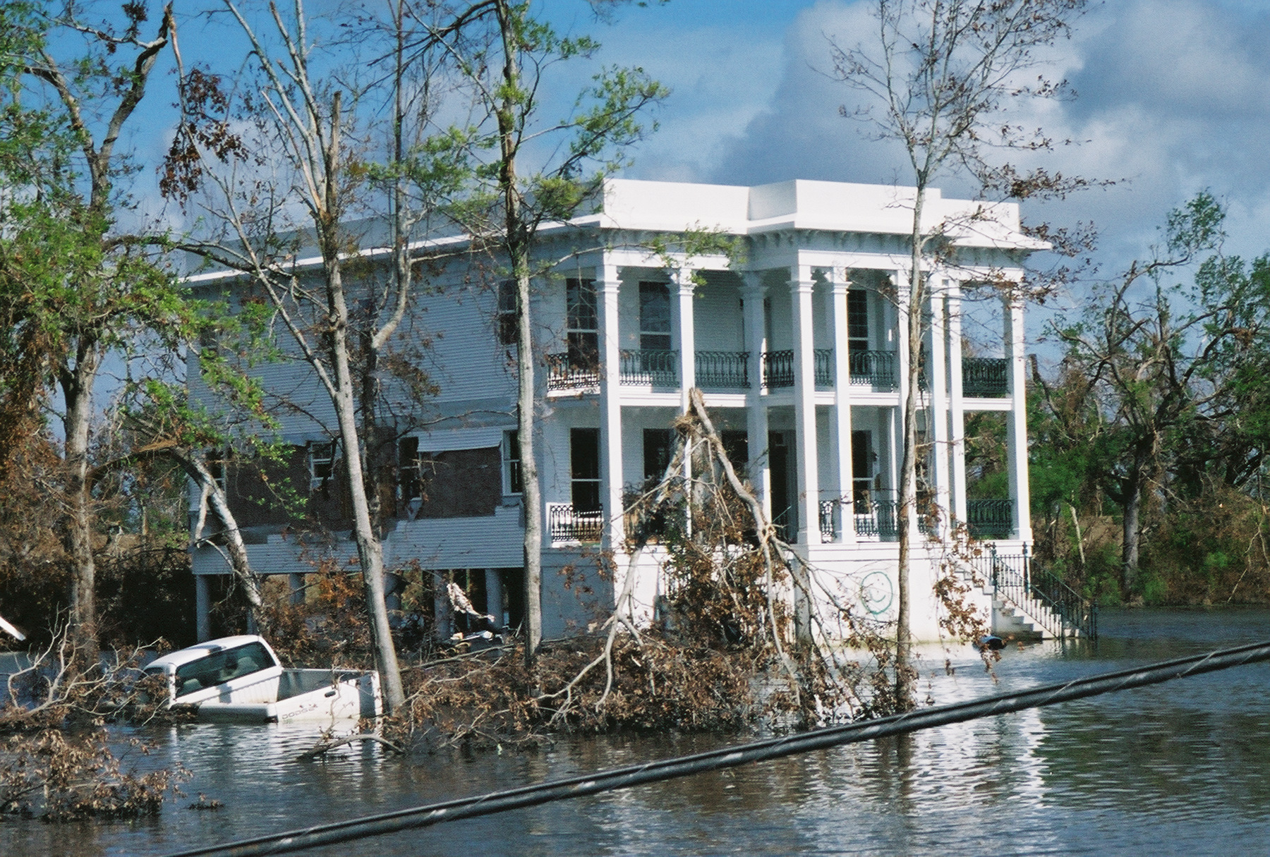
 is a bad deal,” Mark Davis, director of the Coalition to Restore Coastal Louisiana, told me five years ago.
 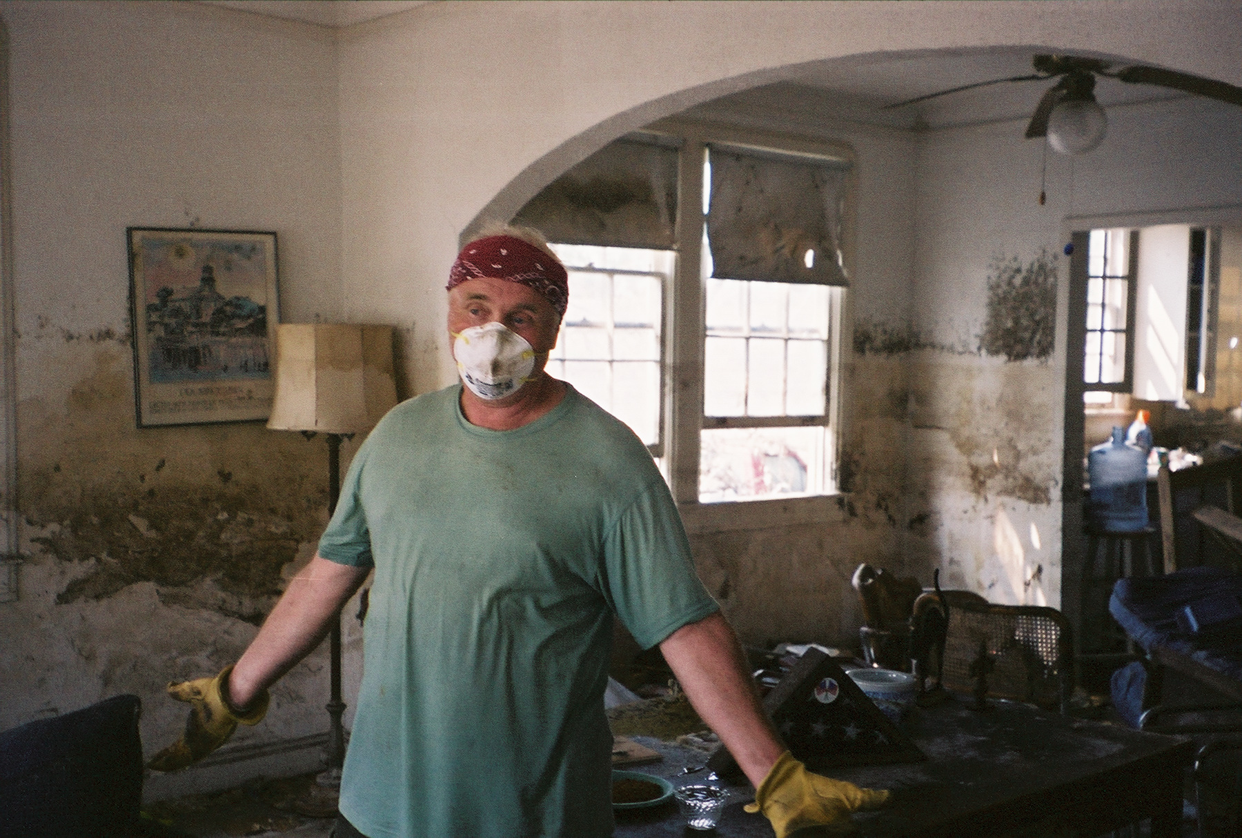 resignation when I take his picture. “I lived in this house 16 years. We’d have been fine if the levee hadn’t broke. We’d be moving back right now.”
 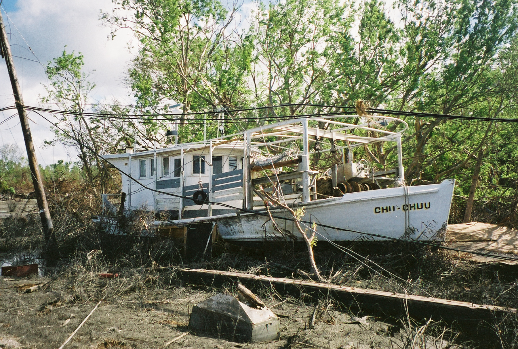 towns of several thousand, like Empire and Buras, got washed away and some oil tank farms ruptured. Where the road’s cut by water, we drive up on the eroded levee and keep going. There are boats on the land, and houses in the water or washed onto the road or turned into woodpiles. At one point where the levee broke and the water poured through, there’s nothing but a field where Diamond, an unincorporated town of about 300 including many trailer-park residents, stood. Those folks never seem to catch a break.
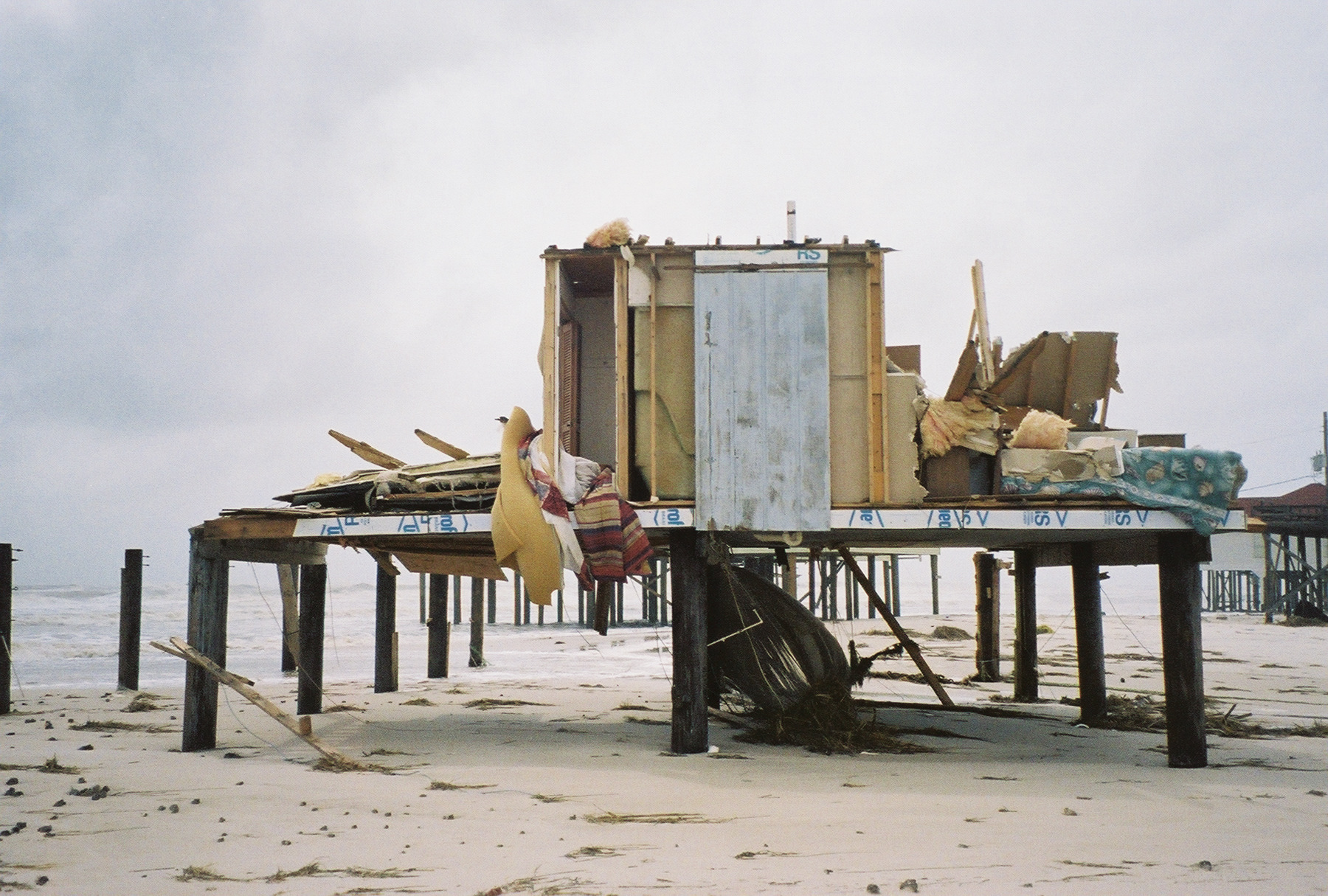
 most of these coastal trees and wetlands festooned with plastic like Tibetan prayer flags (as if monks were praying over dead turtles and seabirds). In Biloxi, along with smashed casinos, historic homes and neighborhoods, I find miles of beachfront covered in plastic buckets and insulation, mattresses, furniture, chunks of drywall and Styrofoam pellets that the seabirds are eyeing as potential snack food. I wave down a truck marked “Department of Natural Resources,” but the guys inside are from Indiana.
 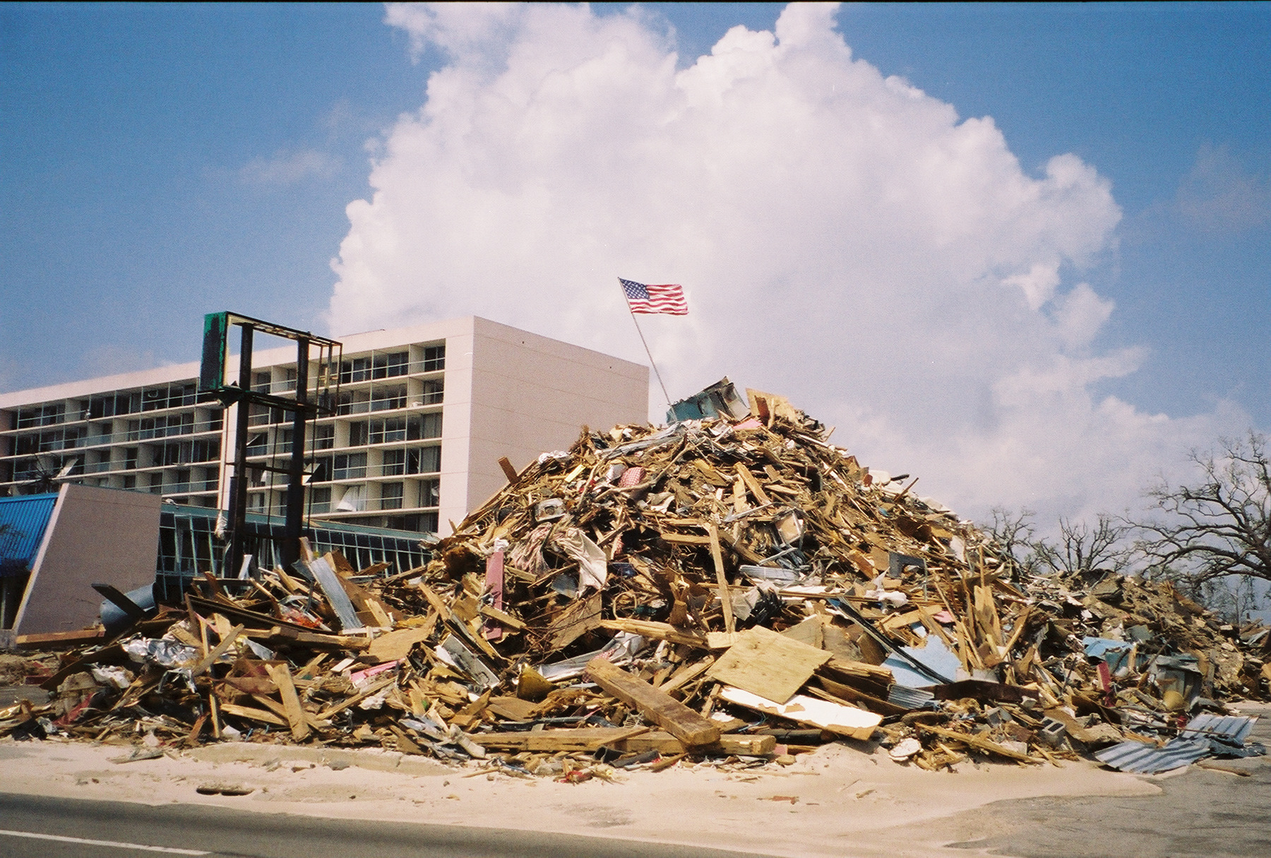 have fared better then the houses in between them.
 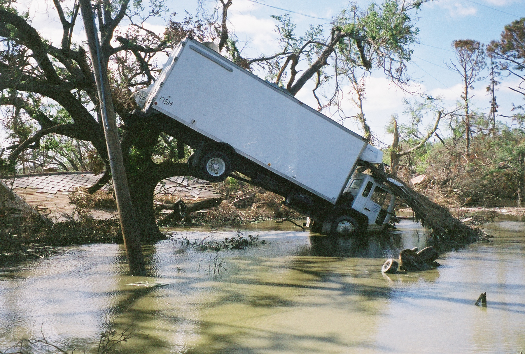 professional mercenary is good training for concierge duty. I sit by the Pelican bar in the lobby looking out the big three-story glass window at the media RVs and SUVs on the street — feeling as if I’ve been in this hotel before in various war zones and Third World capitals like Managua, Tegucigalpa, and Suva.